West Rouge is Toronto's easternmost neighbourhood, bordered by Rouge National Urban Park to the north and east, and Lake Ontario to the south. Detached homes on generous lots, Rouge Hill GO station within the neighbourhood boundary, and federal parkland that begins where the residential streets end. Properties sell from $950,000 to $1.5 million in 2026, with the premium going to park-adjacent addresses and well-positioned lots.
West Rouge is as far east as Toronto gets. The neighbourhood sits between the Rouge River valley to the east, Lake Ontario to the south, Port Union Road to the west, and Kingston Road to the north. It’s a small community of roughly 5,000 residents that occupies the southwestern edge of the Rouge National Urban Park watershed, which makes it one of the most unusual residential addresses in the city: a suburban neighbourhood where the forest begins at the end of some streets and extends north for kilometres without interruption.
Rouge National Urban Park, established as a federal national park in 2015, borders the neighbourhood on the north and east. This designation effectively prevents development in the park lands in perpetuity, which has significant implications for residents of the streets nearest the park boundary. Those addresses have forest as a neighbour permanently. That’s a materially different proposition from a neighbourhood that backs onto currently undeveloped land that could eventually be rezoned.
The waterfront adds a second dimension. Waterfront Trail access is within the neighbourhood boundary, and the Lake Ontario shoreline is genuinely close from most addresses, accessible on foot or by bike. West Rouge is not a beach community in the sense that the Beaches is, with its strip of restaurants and shops, but the proximity to the water is real and daily rather than aspirational.
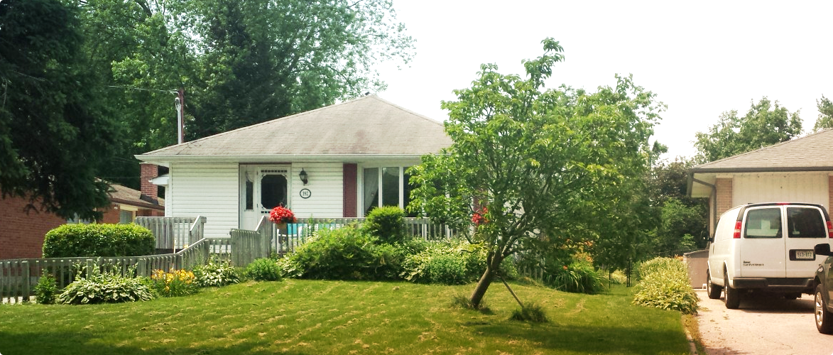
The housing here is a mix of older post-war stock near the lake and newer development that came with the neighbourhood’s growth in the 1980s and 1990s. The overall character is suburban and residential, quiet in the way that end-of-the-city communities tend to be, with a neighbourhood association that has historically been active in protecting the area’s green space character against development pressure.
West Rouge has a broader range of housing types than most Scarborough neighbourhoods. The post-war bungalows and splits are here, similar to what you’d find in Scarborough Village or Tam O’Shanter-Sullivan, but the neighbourhood also includes newer two-storey homes built in the 1980s and 1990s as the area developed toward its current residential density. The result is a housing stock that spans several decades and several formats.
Detached homes are the primary product. In 2026, a bungalow in livable condition is selling in the $950,000 to $1.1 million range. Newer two-storey detached homes on standard lots move from $1.1 million to $1.3 million for average condition and presentation. Premium properties, whether larger lots, renovated condition, or park-adjacent positions, reach $1.4 to $1.5 million. The top of the range here is justified by the park adjacency and the permanence of the natural border to the north and east, which is an unusual feature at this price point anywhere in the GTA.
Lots tend to be generous relative to the price. This is a suburban neighbourhood that was planned with space, and the typical lot sizes run 40 to 55 feet wide on interior streets, with some of the streets closer to the park boundary having larger or more unusual configurations. The depth varies but 120-foot depths are common. That translates to genuine backyard space rather than the compressed lots that inner-city properties have even at much higher prices.
Townhouses exist in smaller clusters within the neighbourhood, primarily from the 1990s development period. They represent the lower entry point, typically selling in the $750,000 to $900,000 range, and attract buyers who want the West Rouge address and the GO train access without stretching to a detached budget. Supply is limited; they don’t come up often.
West Rouge is a low-volume market. The neighbourhood is small and the housing supply is finite, so there are years where very few properties change hands. That low volume makes statistical analysis less reliable than in a high-turnover neighbourhood; you can’t draw firm conclusions from ten transactions with the same confidence you’d draw from 150. Buyers and their agents need to understand this and evaluate individual properties carefully rather than relying on neighbourhood-average data.
The buyer pool is also smaller and more specific than in a typical Toronto neighbourhood. The buyers who actively target West Rouge are usually motivated by the park access, the GO train connection, or the end-of-city quiet, and they’ve often been watching the neighbourhood for a while before a property comes up that fits their criteria. When the right property appears, these buyers act. The low-volume market can create situations where a single property generates disproportionate competition because the specific motivated buyer pool has been waiting.
In early 2026, the market is patient. Days on market run longer than in central Scarborough, and sellers often receive fewer total showings than they would in a higher-density neighbourhood. This is not a sign of weak demand; it reflects the smaller, more deliberate buyer pool. Conditional offers are realistic and home inspections are expected. Buyers have room to do proper due diligence rather than being forced into decisions on compressed timelines.
The GO train factor is a meaningful demand driver. The Rouge Hill GO station on the Lakeshore East line is within the neighbourhood boundary, which gives West Rouge a transit connection that most comparable east Scarborough addresses lack. Buyers who commute to downtown Toronto by GO train specifically target this neighbourhood for that reason, and their presence in the buyer pool creates a demand floor that keeps prices from drifting to pure suburban Scarborough levels.
West Rouge draws a specific and identifiable buyer profile. At its core, this is a neighbourhood for buyers who genuinely value outdoor access, natural landscape, and quiet suburban character, and who are willing to accept being far from downtown in exchange for those things. The buyers who end up here have usually made a deliberate choice rather than a fallback decision. They’ve looked at other options and decided that what West Rouge offers, park access from your backyard, GO train to downtown, lake proximity, isn’t replicated anywhere else in Toronto at this price.
GO train commuters are well-represented. A buyer who works at Union Station or within a short walk of it can be at their desk from West Rouge in 35 to 45 minutes, which is competitive with commutes from many inner-city neighbourhoods once parking, subway crowding, and door-to-door time are honestly compared. These buyers are often making an explicit trade: a larger house, a bigger lot, natural surroundings, in exchange for living far from the city’s commercial and social centre.
Outdoor-focused buyers are the other consistent type. Hikers, trail runners, cyclists, paddlers, and people who want to be able to walk into forest from their own street. Rouge National Urban Park has over 79 kilometres of trails in the broader park area, and West Rouge’s position at the park’s southwestern corner makes it the most practical starting point for most of that trail network. Buyers for whom that matters enough to shape a housing decision come here specifically.
Families with children who want space and safety as primary criteria also appear consistently. The neighbourhood’s quiet character, low traffic volumes on most internal streets, and access to natural play environments make it appealing for families with young children. The school situation is acceptable if not exceptional, and the overall environment is one that many parents describe as having the feel they were looking for.
The neighbourhood is divided informally by Port Union Road, which runs north-south through the area. West of Port Union, the streets are closer to the GO station and Kingston Road, more accessible for transit and daily services but with less direct park adjacency. East of Port Union, streets are closer to the Rouge River valley and the national park boundary, with more natural surroundings and the park access that premium buyers are paying for.
The streets along the northern edge of the neighbourhood, where the residential grid meets the Rouge National Urban Park boundary, are the most sought-after. Lawrence Avenue East and the streets running north from it come to a hard stop at the park. There’s no development pressure north of that boundary and there won’t be, which means those addresses have forest views and trail access that are genuinely permanent features. These properties sell at the top of the price range and they hold value because the asset that drives their premium is protected by federal legislation.
The waterfront streets to the south have a different character. Port Union Road near the lake, and the streets that connect down toward the Waterfront Trail, give residents lake proximity that the northern park-adjacent streets don’t have. Some buyers specifically want both, which the neighbourhood can deliver given its compact geography. A property in the centre of West Rouge can have park trail access to the north and lake access to the south within a ten-minute walk in either direction.
The streets around the Rouge Hill GO station are the most transit-accessible but also the most affected by the rail corridor noise. Train frequency on the Lakeshore East line is significant at peak hours, and properties within earshot of the tracks should be evaluated with that noise environment in mind. It’s not a dealbreaker for many buyers, particularly commuters for whom the proximity to the station is the primary attraction, but it should be part of the consideration rather than a surprise after moving in.
The Rouge Hill GO station is the neighbourhood’s most practical transit asset. Lakeshore East GO service runs from Rouge Hill into Union Station, with the trip taking approximately 35 to 40 minutes during peak hours. This is faster and more comfortable than the bus-to-subway commute from most of Scarborough, and it’s a direct connection to Union Station without transfers. For buyers who work downtown or near Union, the GO train makes West Rouge a genuinely viable address despite its distance from the city centre.
TTC bus service runs on Kingston Road and Port Union Road, connecting the neighbourhood to the broader transit network. The Kingston Road bus (route 12A) provides access east toward Morningside and west toward the Scarborough centre area and the subway system. This is the fallback for trips that don’t involve Union Station, and it’s functional but slow. The all-in transit commute to downtown by bus and subway from West Rouge takes 60 to 80 minutes, which is the honest comparison if you’re not using the GO train.
Car ownership is the practical standard. Kingston Road connects west toward Scarborough and east toward Pickering and the Durham Region. Highway 401 access is via Port Union Road and Sheppard Avenue East at the western end of Kingston Road. The Rouge Valley exchanges on the 401 are within a short drive. For buyers who work in Pickering, Ajax, or eastern Durham, the car access from West Rouge is actually quite good, making the neighbourhood viable for a wider employment geography than its transit connections alone would suggest.
The Waterfront Trail runs through the neighbourhood and provides a cycling route west toward Scarborough and the Beaches, and east toward Pickering and beyond. For residents who cycle recreationally or who are willing to cycle for some commute trips, the trail adds a transportation option that is pleasant in a way that Kingston Road cycling is not.
Rouge National Urban Park is the defining green space feature and it’s worth being specific about what it means for daily life. The park encompasses over 79 square kilometres of forest, river valley, wetlands, and agricultural land stretching north from the Lake Ontario shoreline into Markham and Stouffville. The section immediately adjacent to West Rouge includes forest trails, the Rouge River corridor, and natural habitat that is managed as federal parkland rather than municipal recreation space. It feels wilder and less manicured than a city park.
The park’s trails are accessible on foot from the streets at the northern edge of the neighbourhood. Residents on those streets can be on park trails within a few minutes of leaving their door. The trail network includes routes along the Rouge River, through forest, and up into the broader park system. It’s a genuinely diverse outdoor environment: a morning run in the park is materially different from a morning run in a city park.
The Lake Ontario waterfront provides a second axis of outdoor access. The Waterfront Trail runs along the shoreline and is well-used by cyclists, walkers, and runners. The beach access near Port Union, while not as developed as the Beaches beach in the west end, provides a quieter and less crowded waterfront experience that residents generally prefer for everyday use. On summer weekends the waterfront areas get busier, but they don’t reach the volume of Rouge Beach in the broader Pickering area to the east.
The combination of park access to the north and waterfront access to the south is the neighbourhood’s defining green space advantage and it’s not replicated by any other residential address in Toronto. Buyers for whom outdoor access is a daily priority rather than a weekend option will find West Rouge offers more of it, in more varied forms, than any comparable price point in the city.
West Rouge’s retail situation is honest about the trade-offs that come with living at the city’s eastern edge. The immediate neighbourhood has minimal commercial activity. Kingston Road provides the nearest strip retail: a grocery store, a pharmacy, a few fast food options, and basic service businesses. It covers everyday needs without requiring a long drive, but it’s not a commercial strip that offers much beyond function.
Port Union Village Plaza on Lawrence Avenue East, within the neighbourhood boundary, has a grocery store and supporting retail that handles routine shopping. For most residents, this is the primary everyday retail destination and it’s sufficient for the basics. The scale is suburban neighbourhood plaza rather than regional shopping destination, and that’s appropriate for a community this size.
Scarborough Town Centre is about 20 minutes west by car and handles the regional shopping needs: national retailers, a Cineplex, larger electronics and home goods stores, and a food court. Residents make that trip for anything the local strip doesn’t cover. It’s not a daily destination but it’s accessible enough that the absence of those retail categories locally is not a practical problem.
Restaurant density in the immediate neighbourhood is low. There are a handful of options on Kingston Road, but West Rouge is not a neighbourhood where you’ll walk to dinner at a range of restaurants and then decide where to go. Residents who eat out regularly drive to Scarborough, to Pickering, or into the city. This is not unusual for a community of this size at the city’s edge, but buyers for whom walkable dining is a quality-of-life priority should factor it in honestly before choosing this address over alternatives closer to denser commercial areas.
West Rouge is served by the TDSB’s Rouge area elementary schools. The primary catchment school for most addresses is West Rouge Junior Public School, which feeds into Port Union Community Middle School for grades 6 to 8. These schools are typical of Toronto’s eastern suburban system: community-focused, manageable in size, and diverse without the extreme density of population that some urban schools carry. Parent involvement tends to be high in communities like West Rouge where many families have specifically chosen the neighbourhood for its family-friendly character.
The TCDSB serves Catholic families in the area with separate elementary schools. Boundary verification is essential for both boards; the specific school serving any address should be confirmed through the board’s online tools before making school catchment part of a purchase decision.
Secondary school catchment points primarily to Sir Oliver Mowat Collegiate Institute on Lawrence Avenue East, which is a standard large secondary school with a full program offering. It’s not among the academically ranked schools that drive house purchases in North Toronto, but it has solid programs and the student population is reflective of the diverse east Scarborough community. Some families in West Rouge pursue Specialized High Skills Major programs or the International Baccalaureate at other TDSB schools, which require separate applications and may involve a commute.
The proximity to the University of Toronto Scarborough, about 20 minutes west by car, and to Centennial College’s Morningside campus, are practical considerations for families with older children or buyers who value post-secondary access within a manageable distance. Both institutions are reachable by transit from the Kingston Road corridor, which keeps them accessible to students who don’t have a car.
The federal national park designation for Rouge National Urban Park is the single most significant planning protection affecting West Rouge. Federal parkland is protected at a level that municipal greenbelts and provincial conservation land are not. The boundaries of the park adjacent to the neighbourhood are fixed, and no residential development can occur within the park. Buyers purchasing on the streets that back the park can treat the natural boundary as permanent in a way that’s unusual for Toronto properties adjacent to undeveloped land.
The Kingston Road corridor, as with other major arterials in Scarborough, has a planning designation that encourages intensification over the long term. Mixed-use and higher-density residential development on and immediately adjacent to Kingston Road is the intended planning direction. Properties within the residential grid set back from Kingston Road are largely insulated from this, but the commercial strip character of Kingston Road itself may intensify over the coming decades as the planning framework encourages redevelopment on those sites.
The Port Union area at the southern end of the neighbourhood has seen some recent development activity, with newer residential buildings appearing in the broader Port Union-Kingston Road area. The city’s Official Plan supports continued development in this area given its proximity to the GO station, which is a meaningful transit hub. Buyers near the Port Union Road and Kingston Road intersection should be aware that the planning framework supports continued densification in that immediate area, even if the interior residential streets are stable.
The GO train service level on the Lakeshore East line is relevant to this neighbourhood’s long-term desirability. Metrolinx’s ongoing GO expansion plans include more frequent service on the Lakeshore East corridor. More frequent service from Rouge Hill would directly improve the neighbourhood’s transit profile and is likely to have a positive effect on property values at the margin.
How far is West Rouge from downtown Toronto? West Rouge is approximately 35 to 40 kilometres from downtown Toronto by road, which translates to 40 to 60 minutes by car depending on traffic and the time of day. By GO train from Rouge Hill station to Union Station, the trip takes approximately 35 to 40 minutes at peak hours, making this one of the more practical long-distance transit commutes in the GTA. By TTC bus and subway, the trip takes 60 to 80 minutes. For buyers who commute by GO train, the distance to downtown is functionally shorter than many midtown or east-end neighbourhoods where TTC service is slower. The honest assessment is that West Rouge is far from downtown in geographic terms but the GO connection makes it more practical for downtown commuters than the distance suggests.
What trails does Rouge National Urban Park offer from West Rouge? The park’s trail network accessible from the West Rouge neighbourhood includes the Rouge River Trail, which follows the river valley north through forest and farmland. The Glen Rouge Campground, the only campground within Toronto’s city limits, is within the park a short distance from the neighbourhood boundary. Trail routes connect into Markham and the broader park system to the north, giving experienced hikers access to multi-hour routes without driving to a trailhead. The wildlife in the park includes deer, foxes, coyotes, and a variety of bird species uncommon in urban settings. The experience of walking in the park from West Rouge is genuinely naturalistic rather than a manicured urban park experience, and that distinction matters to the buyers who specifically choose this neighbourhood for the access.
How does West Rouge compare to Pickering for buyers at the same budget? Pickering, just east of the Toronto border on Durham Region’s western edge, offers comparable housing at similar or slightly lower prices, with newer stock in some areas and the Pickering GO station on the same Lakeshore East line. The practical difference for buyers comes down to the Toronto address versus a Durham address, and the specific features of each neighbourhood. West Rouge has the national park adjacency and the waterfront access that Pickering’s equivalent price-point neighbourhoods don’t match. Pickering buyers get slightly newer housing in some areas and the Durham Region lower property tax rate. Toronto buyers specifically targeting West Rouge for the park access are making a choice Pickering can’t replicate. Buyers who are flexible on the national park feature and are price-sensitive should evaluate Pickering honestly as an alternative.
Is flooding a risk near the Rouge River? The Rouge River valley floor is within a regulated floodplain, and properties within the valley bottom are subject to conservation authority restrictions on development and may be at risk of flooding during significant storm events. The residential streets of West Rouge sit above the valley floor and are not in the floodplain designation, but buyers on streets that back directly onto the valley edge should confirm the specific flood risk status of their property through the Toronto and Region Conservation Authority (TRCA) flood mapping tool. Properties within the regulated area carry restrictions on additions and alterations that buyers should understand before purchasing. A review of the TRCA’s floodplain mapping for any specific address is a standard part of due diligence for properties adjacent to river valleys in Toronto.
Buying in West Rouge requires an agent who understands both the neighbourhood’s specific assets and its honest limitations. The park adjacency premium is real, but it has to be assessed property by property because the value of park access varies significantly with proximity and whether the specific lot actually has trail access versus simply being in the same postal code as the park boundary.
The GO train access is the neighbourhood’s most significant practical asset for downtown commuters, and an agent who understands how to communicate that to buyers, and how it justifies price relative to comparable properties elsewhere in east Scarborough, is more useful than one who treats this as a generic suburban neighbourhood.
Due diligence on flood risk for properties near the Rouge River valley, and on permit status for any additions or basement suites, is essential here. The TRCA regulated area affects some properties and not others, and the distinction matters to the purchase decision. A competent agent will identify this at the showing stage rather than after the offer is accepted.
TorontoProperty.ca covers east Scarborough and the GO corridor thoroughly. If West Rouge is on your shortlist, reach out for specific guidance on which streets offer the best combination of park access, GO proximity, and price for your budget.
Street-level knowledge is hard to find online. Our team works in West Rouge every day. They know which pockets hold value, where the school catchment lines actually fall, and what the market is doing right now. Talk to us before you make a decision about West Rouge.
Talk to a local agent